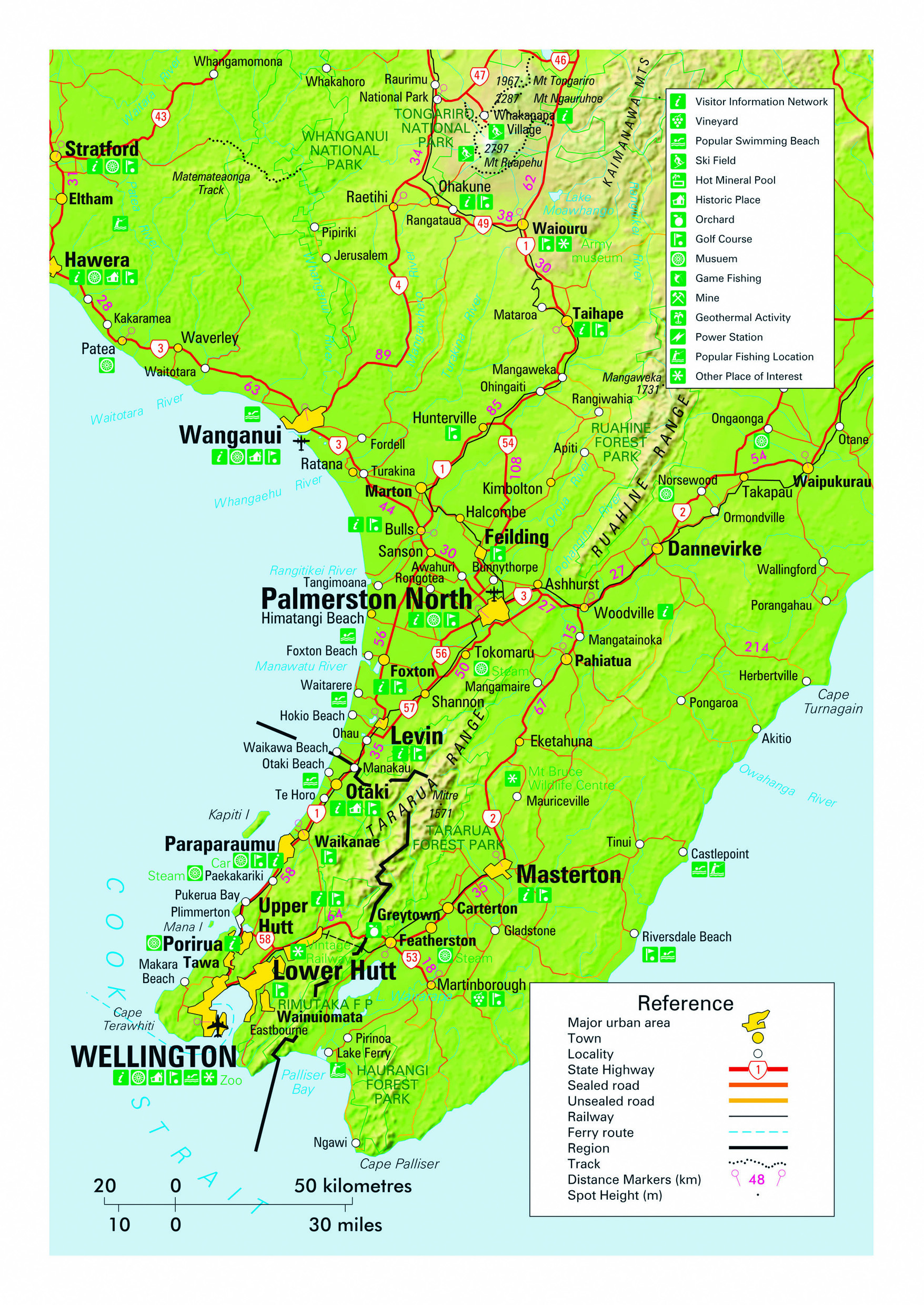
The Wellington region occupies the southern end of the North Island and is divided into three distinct areas. The region is intersected by New Zealand’s major fault line where the Pacific and Australian tectonic plates meet, with the resulting mountains becoming increasing rugged as they stretch southward before re-emerging in the South Island to form the majestic Southern Alps. In the Wellington region the resulting mountains are the Tararua Range that rises to over 1500 m in several places and is often snow capped during the winter months. To the east lies the Wairarapa district, to the west is the Kapiti Coast, while the southwestern corner is occupied by the four cities of Porirua, Upper Hutt, Lower Hutt and Wellington that form the urban area. The region’s population of 521,000 is roughly 80% accommodated within this urban area. They constitute about 11% of New Zealand’s population and are responsible for about 15% of the national GDP.
Climate is temperate maritime with windy weather commonplace and temperatures that rarely climb above the mid 20s or fall below freezing, except in the Wairarapa area where warmer and cooler extremes are experienced. Much of the coastline, including in the heavily urbanised area, is rugged and exposed variously to the gales of the South Pacific Ocean, Cook Strait and the Tasman Sea. Combined with the mountainous interior, this harsh and windswept characteristic is a major feature of the region. The western Kapiti Coast is home to some of the long stretches of unbroken beach that are to be found along much of the North Island’s west coast, and is also the area through which SH1 accesses the Wellington urban area. In contrast the Wairarapa, through which SH2 passes, features a wide area of undulating countryside used for farming and vineyards and is sheltered from the east coast by further ranges of steep hill-country. Independent travellers completing round trips by motorhome have the opportunity to see both the western and eastern sides of the region, along with the urban area with its sprawling harbour side capital city of the nation.
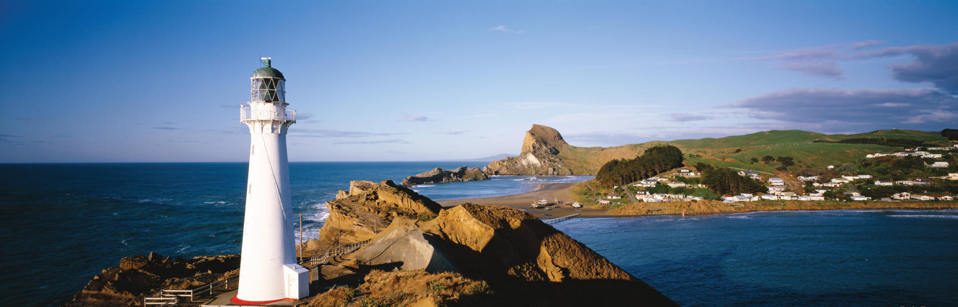
For those who thrive on finding sparsely populated localities in which to contemplate agreeable scenery, Castlepoint is a fine example of a quiet seaside village on the Wairarapa coast of the Wellington region. The settlement is a pleasant 65 km drive along back roads from Masterton and is known for having the tallest lighthouse in the North Island. Although fully automated since the 1980s, the lighthouse was once a popular posting for keepers as Castlepoint is large enough to have its own small school. The stretch of coastline is a great place to linger away from the masses and features a wonderful beach that has hosted an annual horse race for more than 100 years. The local hotel and guesthouse has sites for campervans.
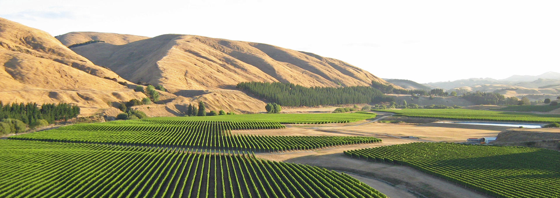
The Wairarapa district is a largely rural area occupying the north-eastern part of the Wellington region. Its western boundary is formed by the Tararua Range that rises to over 1500 m in several places and is often snow-capped during winter months. SH2 passes through the district, connecting Wellington and the Hawke’s Bay cities of Napier and Hastings. The highway has a famously winding stretch as it passes over the Rimutaka Range that separates the Wairarapa from the Wellington conurbation to the south. The district is heavily farmed and forested and features successful areas of vineyards around the settlements of Martinborough, Carterton and Masterton. The inland location often results in very warm temperatures during summer months and visiting the local Pinot Noir wineries is a popular activity on a sunny day. Southern townships in the district are connected by commuter rail services to Wellington City. At Featherston a roadside memorial garden marks the site of a WWII Japanese prisoner of war camp where 48 lives were lost when guards responded to a perceived threat of a riot. Masterton, the district’s largest town with a population of approximately 22,000, is a rural service centre. Further north on SH2 the Mt Bruce Wildlife Centre is one of the county’s premiere native bird conservation centres and makes for a fascinating break in one’s travels.
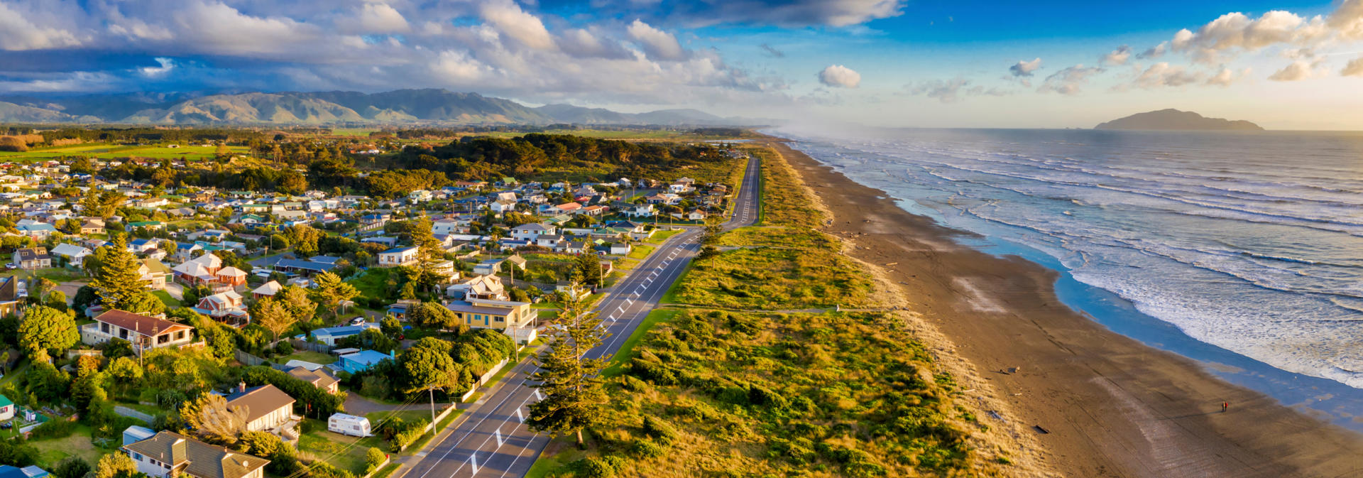
The Kapiti Coast district lies within the north-western corner of the Wellington Region and takes its name from a 10 km long island just off the coast. The district is home to multiple small towns with growing populations attracted to the excellent beaches of the area and the close proximity to Wellington. SH1 provides the main arterial route through the area. This stretch of the highway is one of the first rural highways in the country to be upgraded to expressway standard, providing unfortunate encouragement to transit the area without exposure to its attractions. The settlements and townships of Pukerua Bay (hometown to film director and producer Peter Jackson), Paekakariki, Raumati, Paraparaumu and Waikanae all feature agreeable seaside suburbs for those adventurous enough to detour from the expressway. The superb Southward Car Museum at Otaihanga has over 300 vehicles on display for anyone seeking a trip down memory lane. Tours are available to Kapiti Island which is maintained as a predator free sanctuary to native bird varieties. The coast was home to Te Rauparaha during the early years of European colonisation, chief of the local Ngati Toa tribe who gained notoriety as one of the most feared Maori leaders through his raids of rival tribes as far away as Canterbury. Te Rauparaha is famed for having authored the haka (war chant and dance) Ka Mate, which is the favoured haka performed prior to international matches by New Zealand’s enormously successful All Blacks rugby team.
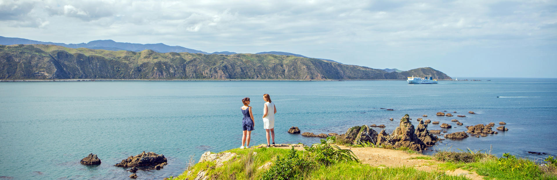
Cook Strait lies between the North and South Islands of New Zealand. The strait is fabled for its currents which are the product of a sea floor that combines sand banks with a canyon system that plunges to 3000 m at its deepest point, combined with high and low tide cycles that are almost directly reversed at the Tasman Sea and Pacific Ocean ends of the strait. While flow direction generally synchronises with the changing tides, during stormy conditions flow can be maintained for several days in the same direction. With only 22 km separating the two islands at their closet point and steep country on both sides, the strait is also known as an impressive funnel for wind. However, having made dozens of crossings while tour coach driving and hundreds of campervan relocations, as founder of New Zealand Frontiers I can reassure anyone apprehensive about making the crossing that despite the fearsome reputation, ferry crossings rarely rate as the roller coaster ride that story tellers would have you believe. Although the creative names bestowed upon the country’s two main islands indicate travel in a northerly or southerly direction when crossing from one island to the other, the alignment of the two actually places the top of the South Island almost 150 km north of the southernmost point of the North Island. The 100 km ferry journey between Wellington and Picton starts and finishes at very similar latitudes. Maori are known to have swum the strait in the early days of European settlement and swimmers aged from 11 to 58 have made the crossing in more recent decades, with attempts always carefully timed to take advantage of tides. The strait is also crossed by three high voltage electricity cables that carry power from the more abundant hydro generation sources in the South Island to the higher population demands of the North Island.
Two ferry companies operate scheduled services across Cook Strait with a combined total of up to 10 daily crossings in each direction during peak periods between the government owned Interislander and the privately operated Bluebridge shipping lines. Journey times vary between three and three and a half hours dependent upon the vessel and, to a lesser extent, sea conditions. Both companies maintain terminals in Central Wellington and in Picton in Queen Charlotte Sound at the top of the South Island, with vehicle check in times one hour in advance of departure. New Zealand Frontiers has an agency agreement with the Interislander who operate the largest vessels and most frequent sailings. Fully flexible bookings can be requested on your motorhome reservation form at discounted rates to those offered on the Interislander website. Cheaper, less flexible fares that are not available through agents - with penalty charges for changes – are available by booking directly with the ferry companies for those with fixed itineraries. The scenic crossing is a highlight of any nationwide tour of New Zealand with comfortable cafes and bars on board vessels that carry up to 1350 passengers.
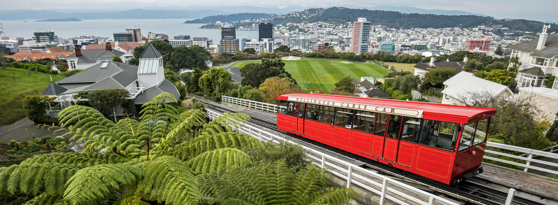
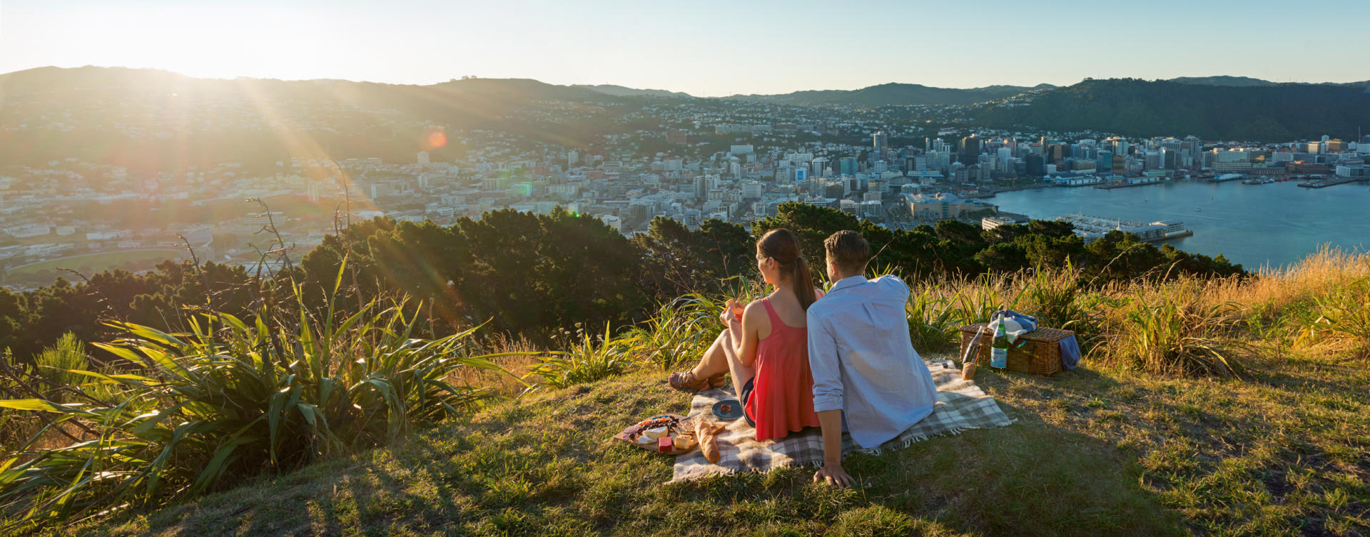
As the world’s southern-most capital city, Wellington maintains a reputation as a windswept, rain lashed city that is regularly shaken by earthquakes and occasionally shivers to the sight of snow on its hills. For many years a local radio station was known as Radio Windy and New Zealand Sign Language continues to refer to the place by forming a ‘W’ with one’s fingers and giving it a shake! However, as a harbour city in which gale force winds are only recorded on 173 days per year, in fine weather the place is as spectacular as it is on bad hair days. The rugged atmosphere, hilly geography, modest population of 215,000 (with approximately 400,000 in the area’s four cities combined) and a cosy, compact CBD have seen the city labelled by international travel guides as The Coolest Little Capital in the World. The sheltered harbour ensured that the area was a favoured point of settlement for Maori from around 1280. Early European settlers were also enthusiastic and established the New Zealand Company in 1839 to sell land in the U.K. before they had even purchased it. The country’s major fault line only misses the CBD by about a kilometre and in 1855 an 8.2 quake raised much of the entire region by several metres. Most of the central city lies on seismically reclaimed land and the main shopping precinct of Lambton Quay actually lies several blocks inland from the location that it acquired its name from. Earthquakes remain a significant consideration and even historic buildings now sit on retro fitted base isolators. The November 2016 Kaikoura Quake cause over one billion dollars’ worth of damage and resulted in the subsequent demolition of several major office buildings. Wellington became New Zealand’s third capital in 1865 and the government buildings of the first country to give women the right to vote remain a major feature. The original Government Building rates as one of the largest wooden structures in the world and sits across the road from the current Parliament House and The Beehive which houses the executive offices. Parliament has had a single chamber since 1951 and currently has 120 Members. Although the Queen remains represented by a Governor General, the only role she retains in the running of the country is by way of signing a symbolic Royal Assent when new laws are enacted. Nearby the interior of the Old St Pauls Cathedral is a magnificent example of timbered Gothic architecture. Also centrally located are the excellent Wellington Museum and the Te Papa Museum of New Zealand. A cable car travels up one of the surrounding hillsides from the main street to a great view point in fine weather, with an option of walking back down through the Botanic Gardens and Lady Norwood Rose Gardens. For those travelling by campervan, a drive to the view point on the summit of the centrally located Mt Victoria is highly recommended, and the harbour side drive through Oriental Bay and out around the Miramar Peninsular affords superb views of Wellington’s wild, salt encrusted coastline. This scenic route also takes explorers by the local Peter Jackson’s modest Weta Cave, where creations by his special effects workshop for the Lord of the Rings trilogy can be viewed, and past the city’s airport, where passengers only release their grip on their seats to applaud the pilot on windy days.
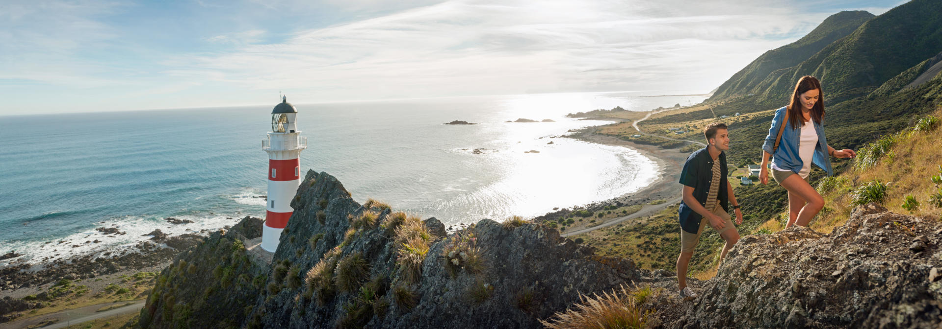
Cape Palliser offers a wonderful opportunity for those on more leisurely independent motorhome travels to get seriously off the popular tourist routes. Located at the southern-most point of the North Island, the cape and its lighthouse stand guard over an often windswept coastline. Offshore the ocean floor plunges to 3000 m at the entrance to Cook Strait. From the road end an energetic climb up a flight of 258 steps takes one to the 1897 lighthouse. In good weather the snow capped Kaikoura Ranges can be seen 150 km distant in the South Island. Those travelling with New Zealand Frontiers will benefit from the ability to freedom camp beneath the sweeping beacon of the light due to all our vehicles being fully self-contained. Nearby on this isolated coast seal colonies nestle beside the road and the tiny settlement of Ngawi features a photogenic fleet of commercial fishing vessels sitting on trailers and hooked up to the bulldozers used to launch them.