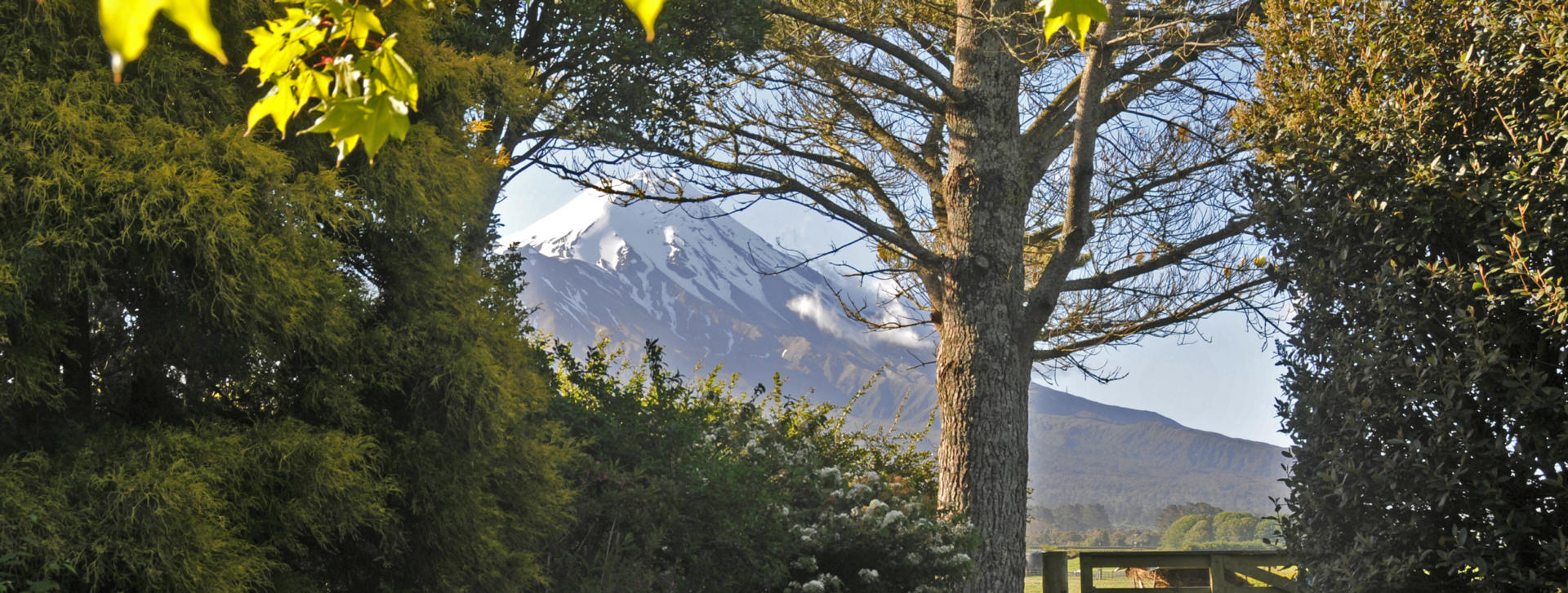
Taranaki is the North Island’s western-most province and is known as a lush region famed for being presided over by the particularly photogenic cone of a stratovolcano. Although the mountain features a major secondary peak on one flank, from many perspectives Mt Taranaki is perfectly symmetrical and it is often quoted as being the second most conical mountain in the world after Japan’s Mt Fuji. Indeed the region was the setting for the 2003 movie the last Samurai that starred Tom Cruise, Timothy Spall and Billy Connolly. The Taranaki region features an oceanic climate that rarely sees temperatures rise into the high 20s during the summer months and often experiences temperatures of below 10 degrees in winter. As with most of New Zealand, overnight frosts are not uncommon during the winter months. Snowfall is confined to the mountain which hosts a club operated ski field.
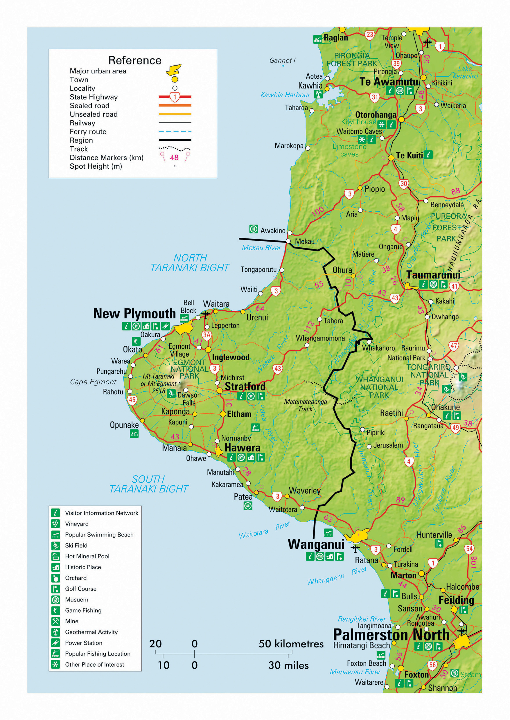
Rainfall in the region varies considerably due to the presence of the mountain, but the entire province enjoys a lushness that permits intensive farming and produces around 10% of the 200 billion litres of milk produced annually in New Zealand. The Fonterra Dairy Cooperative’s factory at Whareroa near Hawera currently processes up to 14 million litres of milk daily, making it among the largest in the world. The moist climate also supports the region’s reputation for having a superb selection of gardens to visit and a major garden festival is held in November each year. Taranaki is also home to 90% of New Zealand’s predominantly offshore oil and gas production, with the industry supplying most of the country’s demand and contributing over one billion dollars in export revenue annually. Taranaki’s only city of New Plymouth is located in the north on the coastline of the North Taranaki Bight and accounts for 50% of the region’s population of 120,000 people. SH45 forms a picturesque 105 km arc around much of the coastline and has been themed as the Surf Highway in reference to another of the region’s attractions for hardy, wetsuit wearing primates. SH3 also conveniently passes through the region and connects Taranaki with the Manawatu-Whanganui region to the south and the Waikato region to the north. Independent travellers exploring the North Island by motorhome are faced with western, central and eastern options to choose their north and southbound routing options from and often elect to miss Taranaki. The fact that the region is relatively overlooked only enhances its attraction as a thoroughly enjoyable corner of the world to visit.
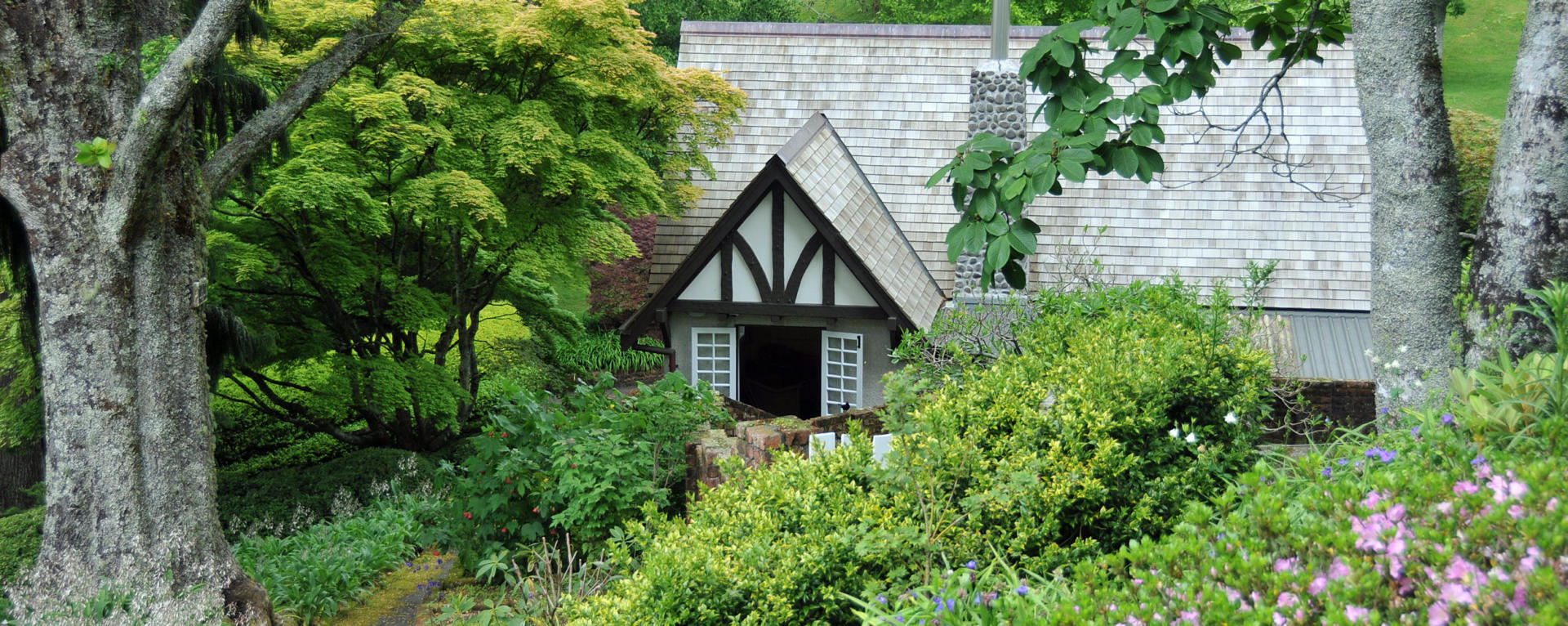
New Plymouth is a pleasant coastal city located in the north of the Taranaki region that takes its name from the origin of some of its early European settlers. It is home to a population of approximately 60,000 and serves as an important service centre for the surrounding oil, gas and dairy industries. The city boasts the impressive contrast of extensive sandy beaches and the snow-capped cone of Mt Taranaki as backdrops – though inclement weather has been known to leave visitors questioning locals as to whether their mountain is in fact a myth. A 13 km long beachfront path has become one of the New Plymouth’s popular attractions and incorporates the spectacular Te Rewa Rewa Bridge and Wind Wand features. The city is also home to the acclaimed Puke Ariki Museum and nearby Govett-Brewster Art Gallery. The Taranaki region enjoys a reputation as having some of New Zealand’s finest gardens and several of these lie within the environs of New Plymouth. The extensive 52 Ha Pukekura Park reaches into the CBD and includes a lake with its own tea house. The internationally recognised Pukeiti Rhododendron Gardens cover 360 Ha and include a café and over 20 km of walkways, while Tupare Gardens are also a highly recommended haven of serenity.
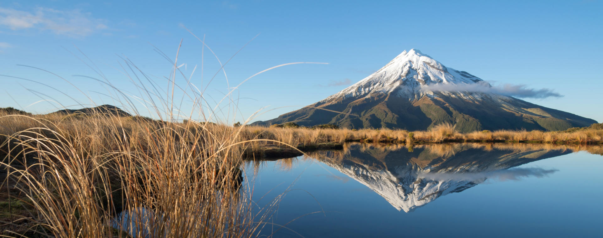
Centre-piece of the Egmont National Park is the 2518 m peak of Mt Taranaki that rates as the North Island’s second highest mountain. Named Mt Egmont after a recently retired First Lord of the Admiralty by Captain James Cook on his 1769-70 circumnavigation of the country, the mountain is now more popularly known by its original Maori name as Taranaki – a reference to its shining peak that is snow-capped for much of the year. The mountain has a violent volcanic history that includes multiple significant collapses of the cone. Ash eruptions took place around 1755, while the appearance and collapse of a lava dome around 1860 is currently the most recent activity. The area within a 10 km radius of the summit forms one of New Zealand’s smaller national parks at 342 sq km, with its densely forested circular boundary forming a stark contrast to surrounding farm land when viewed from the air. The park offers superb hiking opportunities with access from several points on its circumference. Road access extends to 902 m at Dawson Falls with easy walks nearby and the opportunity to overnight in a truly spectacular location. The East Egmont road end extends almost half way up the mountain to 1182 m, providing access to the Maunganui ski field and more walks with superb views. On the northern flanks of the mountain further walks offer access to the Poukai Tarns, one of the national park’s most photographed features. For experienced hikers, you may even wish to consider joining the elite club of New Zealand Frontiers clients who have completed the day trek to the summit and back!
Please note that the rapid changeability of weather in New Zealand means that all hikes require responsible preparation. It is no exaggeration to say that a cloudless morning can transform to falling snow within 30 minutes, at any time of the year. Advice should be sought from the Department of Conservation where intentions should be registered and overnight accommodation in huts can be paid for and booked if required. Sturdy footwear should be worn, warm clothing packed and food carried even for short walks in sunny weather. On any walk of several hours in duration, hikers are well advised to travel prepared to overnight and carry supplies accordingly.
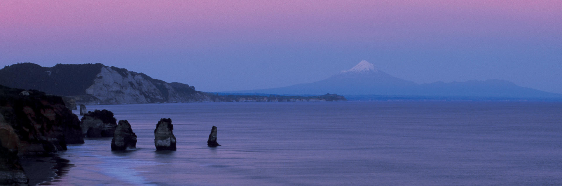
Taranaki’s Surf Highway follows SH45 for 105 km around much of the region’s western coastal circumference. It offers an opportunity to get away from more heavily traveled tourist routes and experience some marvelous scenery and a string of sleepy small towns. Many of the beaches encountered along way have surf breaks that feature on the bucket lists of any serious Kiwi surfer. The beach at Oakura is close enough to New Plymouth to rate as one of the most popular in Taranaki. Cape Egmont’s lighthouse is famously photographed looking inland to achieve the novelty of Mt Taranaki’s symmetrical form as a backdrop in preference to any hint of its nautical role. Nearby Parihaka is an historic site of peaceful resistance by its Maori population in 1881 to the acquisition of their land by European settlers that has become a symbol of grievances surrounding the disposition of Maori communities from their land during New Zealand’s colonisation. The township of Opunake, population of just over 1000, features a proud statue of Peter Snell, their most famous local son who won three Olympic gold medals. The southern end of the highway terminates at Hawera where the 12,500 inhabitants constitute the second largest town in the Taranaki region.