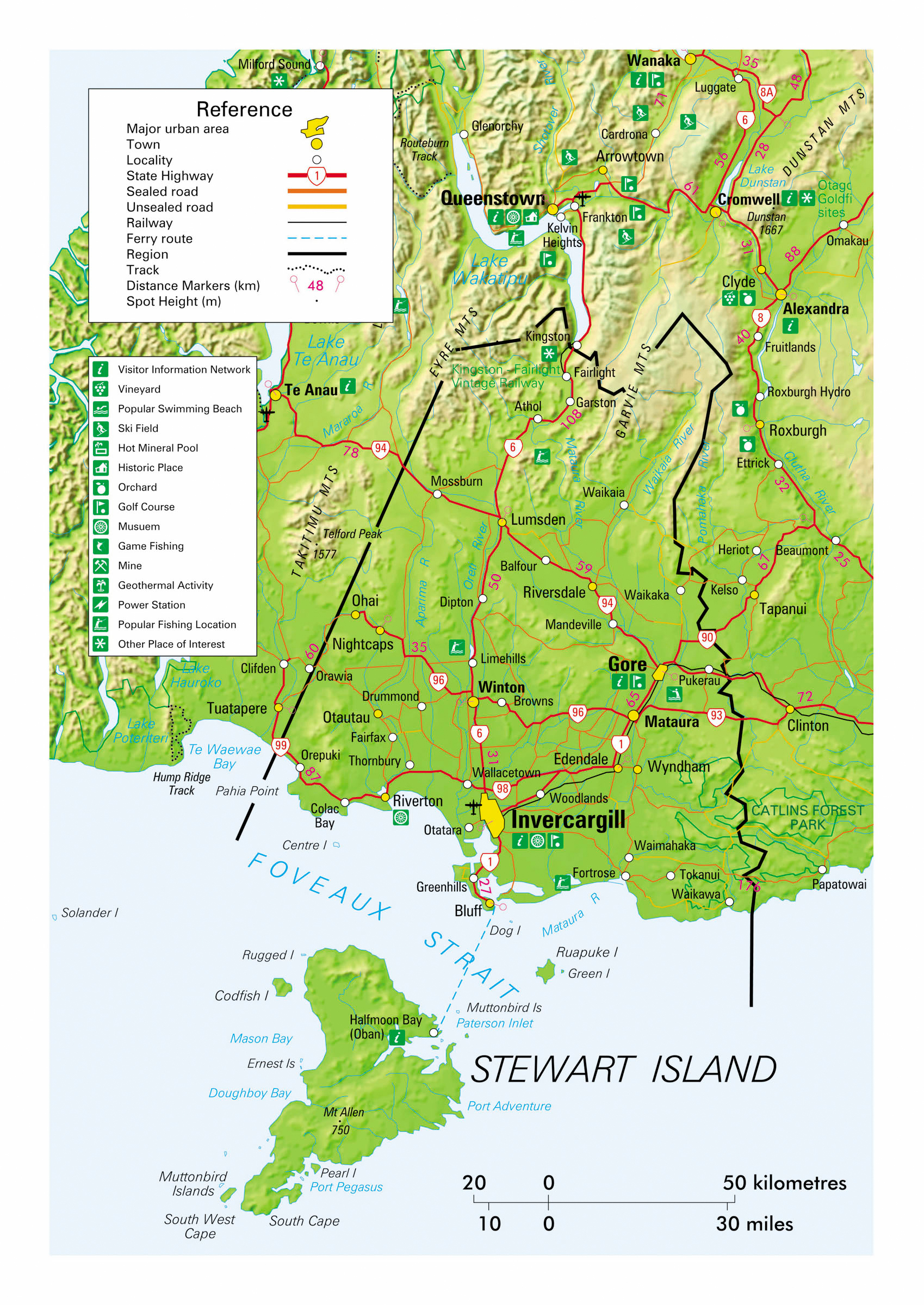
As the name suggests, Southland is New Zealand’s southern-most region and rates also as one of the largest and most sparsely populated. Just over 100,000 people live within the triangle of the south-western corner of the South Island bounded by almost the entire south coast of the island and the lower third of its west coast. For a distance of 50-80 km inland from the entire west coast of the region the land is rugged, isolated alpine country penetrated by over a dozen massive fjords (geologically misnamed locally as sounds) and set aside as the 12,607 sq km Fiordland National Park. In contrast, much of the remaining 18,588 sq km of the region is sheep and dairy farmland. Southland also incorporates New Zealand’s third largest island – Stewart Island – that lies just off the south coast. The region is home to the country’s deepest lake (462 m), several waterfalls of over 500 m in height and the world’s largest dairy factory that processes up to 15 million litres of milk daily.
Climate is generally wetter and cooler than elsewhere in the country with snow falling to sea level in winter months and temperatures rarely rising above the mid 20s in summer. Rainfall can exceed seven metres in the western fjords but is commonly below two metres in farmed areas of the region. Half of Southland’s population live in the largest city of Invercargill and, as with other rural extremities of the South Island, the population remains disproportionately Pakeha (of European origin) at 85%. The region is the only one in New Zealand to have a local accent which is characterised by a rolling of ‘r’ sounds. For independent visitors travelling by motorhome, Southland is vast, unhurried and blessed with magnificent scenery that provides a driving experience ranging from rolling countryside to windswept coastal byways and one of New Zealand’s most famous alpine routes.
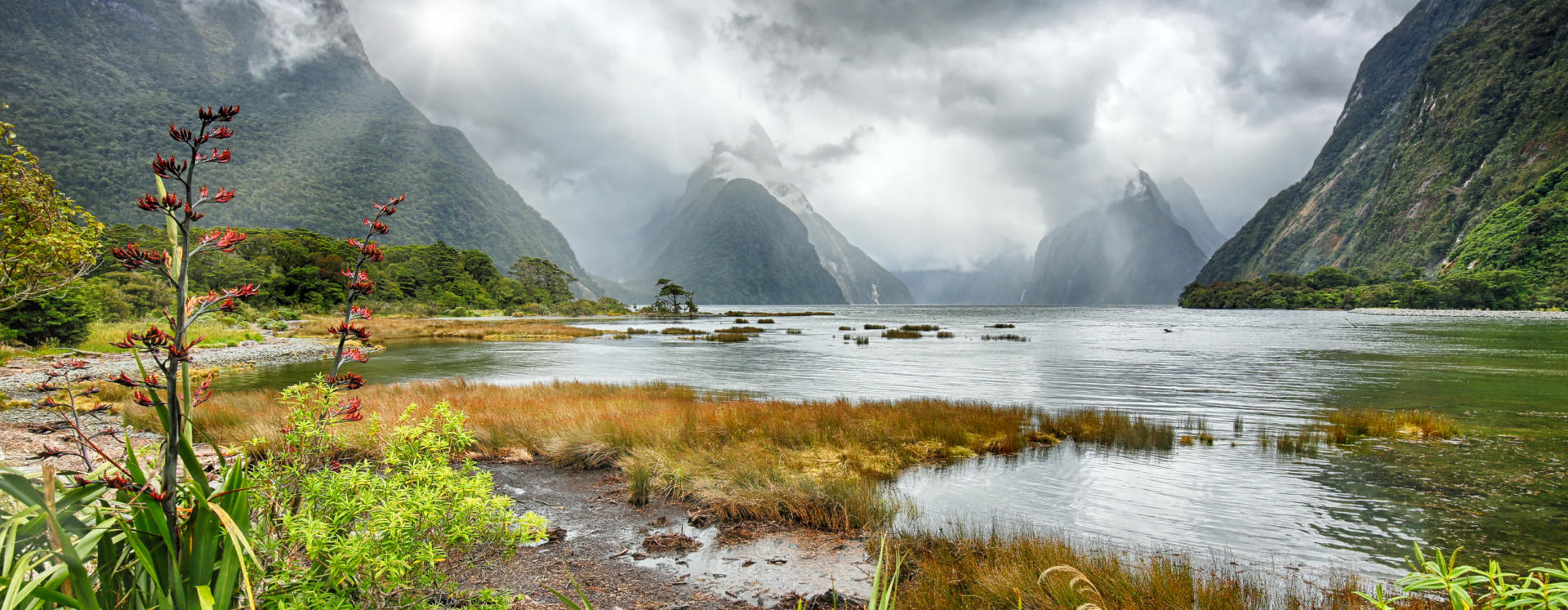
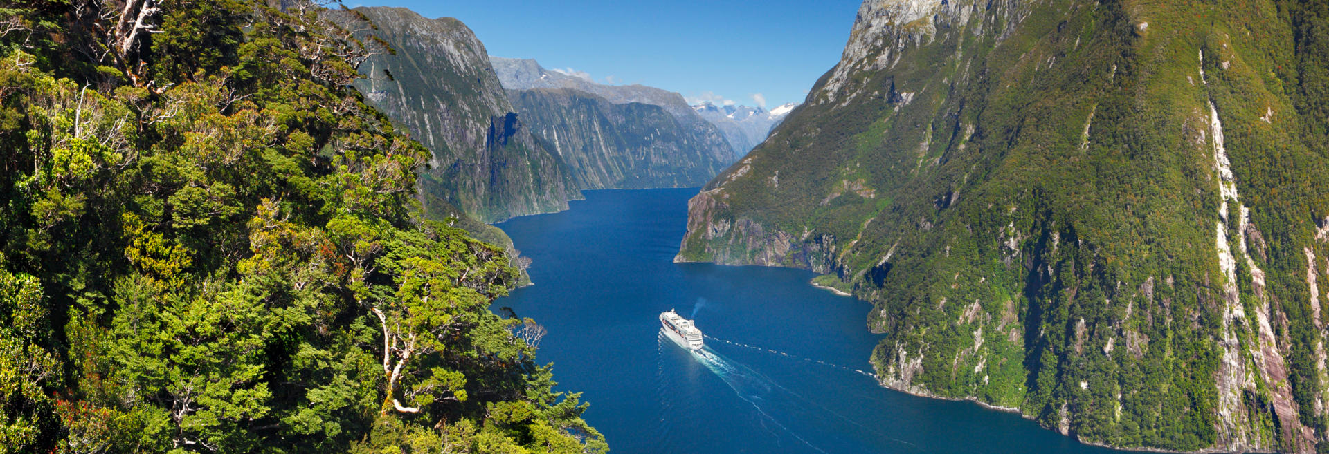
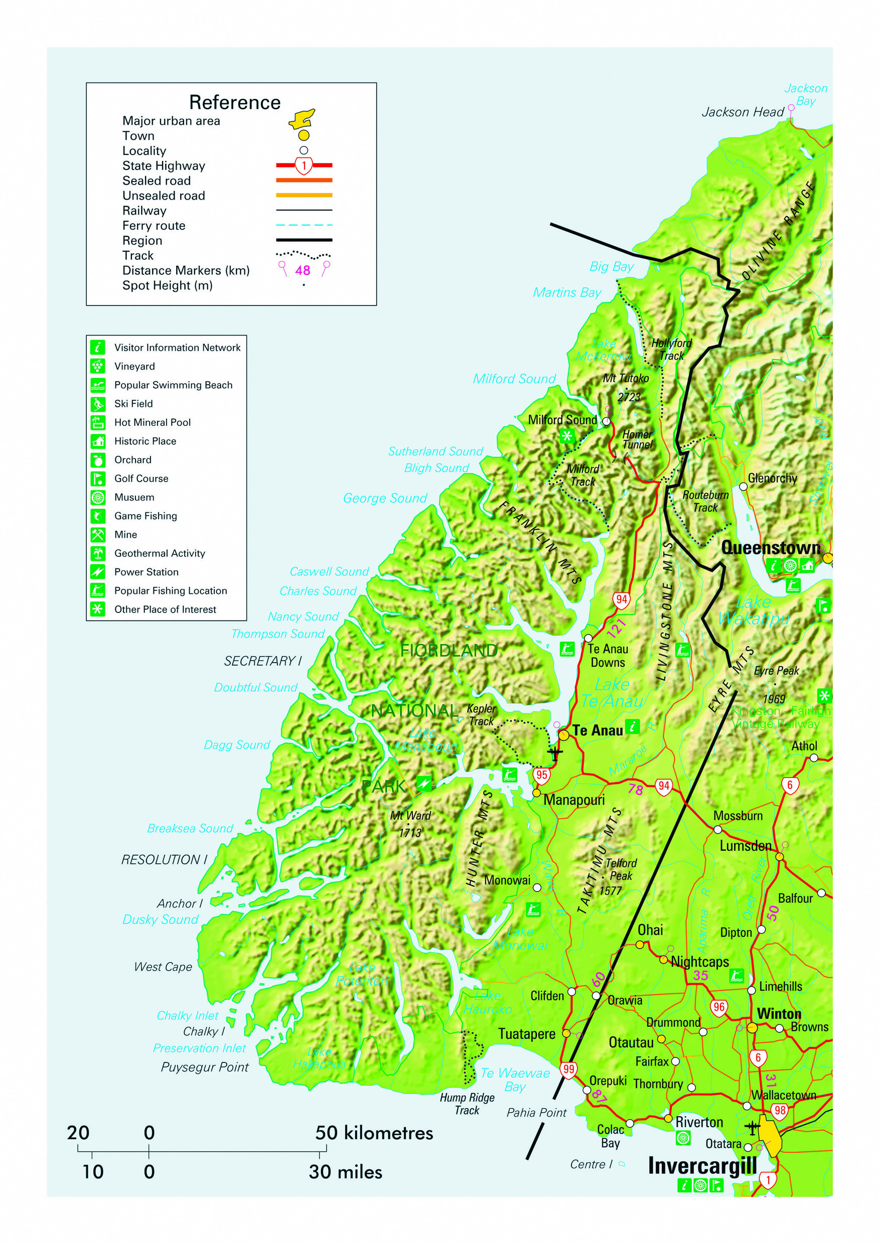
In a country revered for its scenery, Milford Sound is truly one of the gems in New Zealand’s crown. This pristine and supremely photogenic location is reached either by scenic light aircraft or helicopter flight, by coach tour or in the comfort of your own motorhome, and less commonly by cruise ship or with the help of a sturdy pair of boots via the world famous Milford track. Each option has its own distinct benefits, but for independent travellers embarking on a nationwide road trip of three weeks duration or longer, Milford is a ‘must do’ inclusion and the option of self-driving will take you along a road that will remain a highlight of your lifetime. The 120 km highway from Te Anau was partially completed as a government employment project during the recession of the 1930s. It crosses the Main Divide that provides occasional monumental earthquakes, and through the 1.3 km Homer Tunnel located at 945 m that was finally opened in 1952. Photo stops and opportunities for short walks along the route at places such as Te Anau Downs, Mirror Lakes, Knobs Flat, Cascade Creek, Pop’s Lookout, Monkey Creek and the Chasm ensure that one can easily spend a day just getting to or from the sound. A superb strenuous half-day walk to Key Summit on the Routeburn track is available from The Divide. Overnighting opportunities in Department of Conservation campsites along the route or at a holiday park in Milford Sound facilitate the highly recommended option of dedicating a full day to the road journey. The 16 km long fjord is the northern-most (and smallest) of a string of 15 fjords that penetrate a 200 km stretch of the south-western South Island’s coastline, and is the only one to have direct road access. The area is renown for the rainfall that adds dozens of new waterfalls to the permanent ones within hours of rainfall commencing. Milford Sound’s small settlement receives over six metres of rainfall annually, making it the wettest inhabited place in the country. Despite this, rainfall occurs on only roughly half the days in any month throughout the year and visiting under both blue and grey skies is an equally religious experience. Vertical rock faces rise more than a kilometre directly from sea level, the centrepiece majestic Mitre Peak rises to 1683 m, and glacier clad peaks rise to over 2700 m within the immediate vicinity of the fjord. Rainfall and snow melt that cascades down the sides of this rugged alpine landscape, if not blown skyward before reaching its destination, provides a layer of tannin darkened fresh water up to 10 m deep on the surface of the fjord.
Milford Sound is just one example of how New Zealand Frontiers is well placed to provide clients with useful advice that exceeds the service offered by other rental companies. Most visitors to Milford are only able to budget a day for the experience due to having tighter itineraries than those enjoyed by people travelling by campervan, and as a result choose to join a day tour by coach from distant Queenstown. This results in a daily pulse of traffic along the route which reaches its peak between Te Anau and Milford between 0900 and 1200. Limiting the distance covered by staying in Te Anau and travelling outside these hours greatly enhances enjoyment of both the drive and the photo opportunities en route. While the cost of providing scenic flights results in these options being expensive, the absolutely unsurpassed experience of taking a helicopter flight through Fiordland's breath-taking scenery or of landing alongside a remote alpine lake guarantees that the financial outlay is the last thing you remember. Flights can be taken from either Te Anau or Queenstown as an alternative to the road trip, or more affordably from Milford Sound once you’ve completed the memorable drive in.
The road descent into Milford Sound from the Homer Tunnel is one of a handful of prolonged steep gradients in New Zealand where brake pad heating is a safety issue. Drivers should ensure they are familiar with selecting a lower gear to utilise engine braking and should employ this technique accordingly. Drivers are also advised that the Milford Road is subject to occasional closures due to inclement weather or avalanche risk. Advice on current highway conditions throughout New Zealand can be found on the New Zealand Transport Agency’s Journey Planner website.
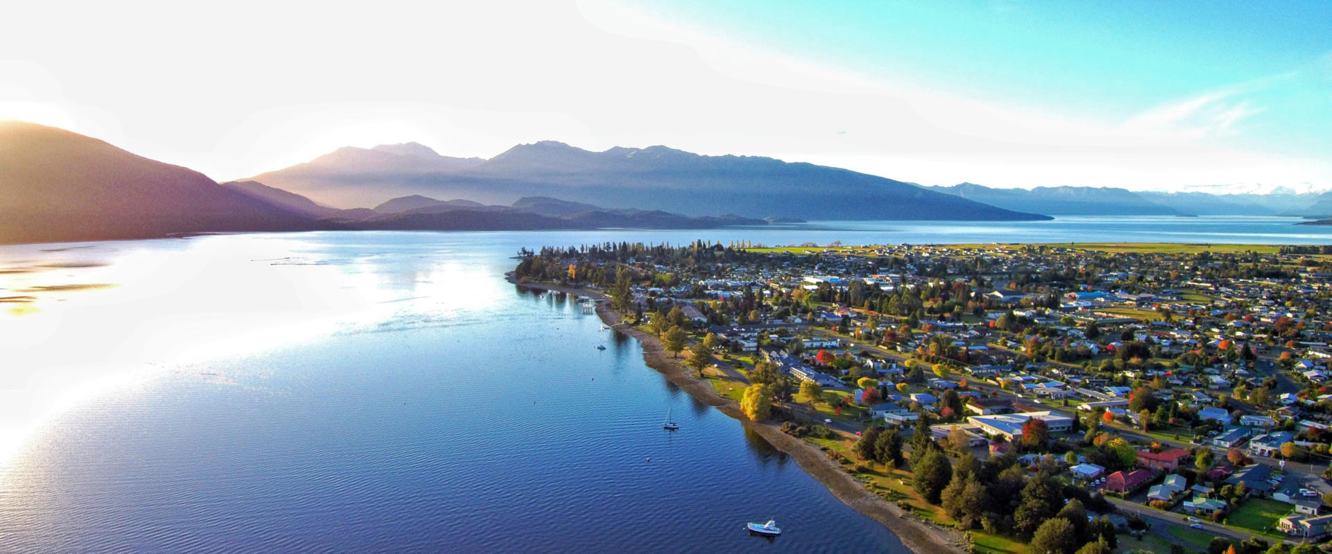
Te Anau is a peaceful lakeside town, with wonderful views of the Fiordland National Park, which has avoided much of the development of other semi alpine towns. It is situated on the shores of New Zealand’s second largest lake, from which it takes its name, and serves as a great departure point for the 120 kilometre drive to Milford Sound. Te Anau is also used as a base for hikers embarking upon the multi-day 54 km Milford and 60 km Kepler tracks, both of which are accessed by local ferry operators and offer unsurpassed scenery for those of fitness levels and on sufficiently leisurely itineraries to be able to incorporate such an experience into their travels. A shorter stroll along the unhurried lakeshore of the 2000 inhabitant township, both by day and under the sparkling skies of a crystal clear night is equally rewarding. Cruises can also be taken to visit glow worm caves across the 344 sq km lake. The Murchison Mountains of the Fiordland National Park, adjacent to Te Anau, are a home of the endangered Takahe large, flightless alpine hen that has been successfully saved from the brink of extinction to number over 400 birds. The Te Anau Bird Sanctuary provides an excellent opportunity to view Takahe and other native bird species such as the large forest parrot the kaka and alpine parrot the kea. Te Anau also boasts a splendid opportunity to visit an alternative to big city cinemas, with the Fiordland Cinema including a bar and café and featuring hourly screenings of the breath-taking Ata Whenua movie about the rather acceptable enormous national park the locals live on the door step of. Nearby Manapouri township (population less than 300 people) is just 20 minutes’ drive away and offers even more peaceful holiday parks on the shores of its own 142 sq km lake.
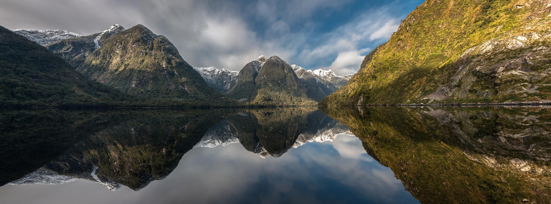
At 40 km in length Doubtful Sound is the second longest of the fjords that indent the alpine wilderness of the South Island’s south-western corner. Located more than 100 km south of Milford Sound, Doubtful Sound is also New Zealand’s deepest at 421 m. Although no direct road access exists, the fjord can be reached by ferry ride across Lake Manapouri to a 21 km construction road that connects Lake Manapouri’s Western Arm with Deep Cove in Doubtful Sound. The road climbs from the lake’s elevation of 178 m to 671 m at Wilmot Pass before descending to sea level at Deep Cove, and was built to facilitate construction of the Manapouri Power Station deep inside the granite of the surrounding mountains. For independent travellers on slower paced road trips, Doubtful Sound offers a wonderful alternative to the more popular Milford Sound, with options for overnight cruises and kayak tours in this area of splendid isolation. The fjord is enormous with three arms to its south and two further fjords branching off its northern side providing a total shoreline of over 200 km. As with Milford Sound, rainfall that exceeds seven metres in some regions of the fjord creates a layer of almost fresh water on the surface that varies between two and ten metres in depth. A resident population of dolphins, along with Fiordland crested penguins, fur seals and even whales are encountered in an environment that sees lofty waterfalls tumble down surrounding densely rain-forested mountain sides and sheer rock faces.
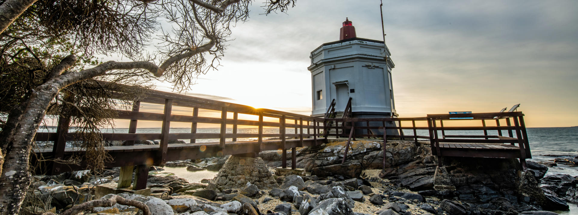
With a population of just over 50,000 people, Invercargill holds the titles as New Zealand’s most southerly and westerly city, and indeed rates as one of the most southern cities in the world. The original settlement was established as a service town for the inland gold rush of the 1860s, in an area frequented by the sparse populations of South Island Maori. As one of New Zealand’s coolest, cloudiest and windiest places, once the gold rush was over it took until the rapid growth of dairy farming in the area since the 1990s and the arrival of a gregarious mayor from Auckland who remains in power a quarter of a century later to boost the local economy. A former student activist, Mayor Tim Shadbolt is credited with initiating sponsored tuition fees at the local Southland Institute of Technology that has also contributed to the city’s change of fortunes. A nearby smelter at Tiwai Point uses 13% of the country’s electricity output to produce some of the purest aluminium in the world, and the dairy factory at Edendale is rated as the largest in the world with a processing capacity of 15 million litres of milk per day. Invercargill has an excellent collection of transport museums that provide quality reminiscing for visitors, including the Bill Richardson Transport World and the Classic Motorcycle Mecca. The later capitalises on fame generated when Anthony Hopkins played local hero Burt Munro who raced The World’s Fastest Indian motorcycle on the nearby Oreti Beach. 30 km south of Invercargill, the port township of Bluff stands on the shores of Foveaux Strait that separates the South Island from Rakiura / Stewart Island. Magnificent views are available from the lookout atop Bluff Hill of Stewart Island and the township below that is hometown to Peter Arnett who provided CNN’s ground breaking live coverage of the Gulf War from Baghdad.

Rakiura / Stewart Island is New Zealand’s third largest island and lies 30 km south of the South Island. It is approximately 70 km in length and covers 1746 sq km, of which 85% is set aside as national park. The population of 400 people all live in the only settlement on the island, named Oban after its namesake in Scotland. A total of only 28 km of roads on the entire island is far surpassed by 280 km of hiking trails. Although commercial fishing remains an important local industry, the opening of Rakiura National Park by Sir Edmund Hillary in 2002 has ensured that showcasing the island’s remote wilderness via cruises and a network of hiking trails is now the mainstay of the local economy. Visiting the island is a viable option for independent travellers on leisurely road trips with up to four ferry departures daily crossing Foveaux Strait from Bluff during summer months and the ability to leave your motorhome at the ferry terminal for either day or overnight excursions. Popular cruises visit Ulva Island on Paterson Inlet, where kiwi, kaka, penguins and seals are commonly seen.